In Part 8 of our RiNo Infrastructure series, we take a look at the improvements proposed for 35th Street, a key east-west connector for the River North neighborhood. Previous posts in this series include RTD’s 38th & Blake Station followed by Part 1: 35th Street Pedestrian Bridge, Part 2: 38th Street Pedestrian Bridge, Part 3: Brighton Boulevard Reconstruction, Part 4: River North Park, Part 5: Delgany Festival Street, Part 6: River North Promenade, and Part 7: RiNo Pedestrian Bridge.
What is a woonerf? It’s a Dutch term (pronounced VONE-erf) for a street that is designed primarily for pedestrians and bicyclists while still allowing motor vehicle access at slow speeds. Popularized in Europe, a woonerf functions as a shared, social space somewhat like a linear plaza while still providing local access to vehicles. A woonerf design typically uses more subtle infrastructure elements such as bollards, landscaping, and different paving materials to distinguish the areas where pedestrians, bikes, and vehicles travel rather than the traditional curb, sidewalk, and bike lane.
35th Street between Arkins Court and Wazee Street is a perfect candidate to be redesigned as a woonerf. First, it isn’t a through street for motor vehicle traffic; it’s only four blocks long and is blocked by the river on one end and railroad tracks on the other. Second and more critically, 35th Street is identified as a prime east-west pedestrian/bike corridor through RiNo as it will connect the RiNo Pedestrian Bridge over the river with the 35th Street Pedestrian Bridge over the railroad tracks and run adjacent to the planned River North Park.
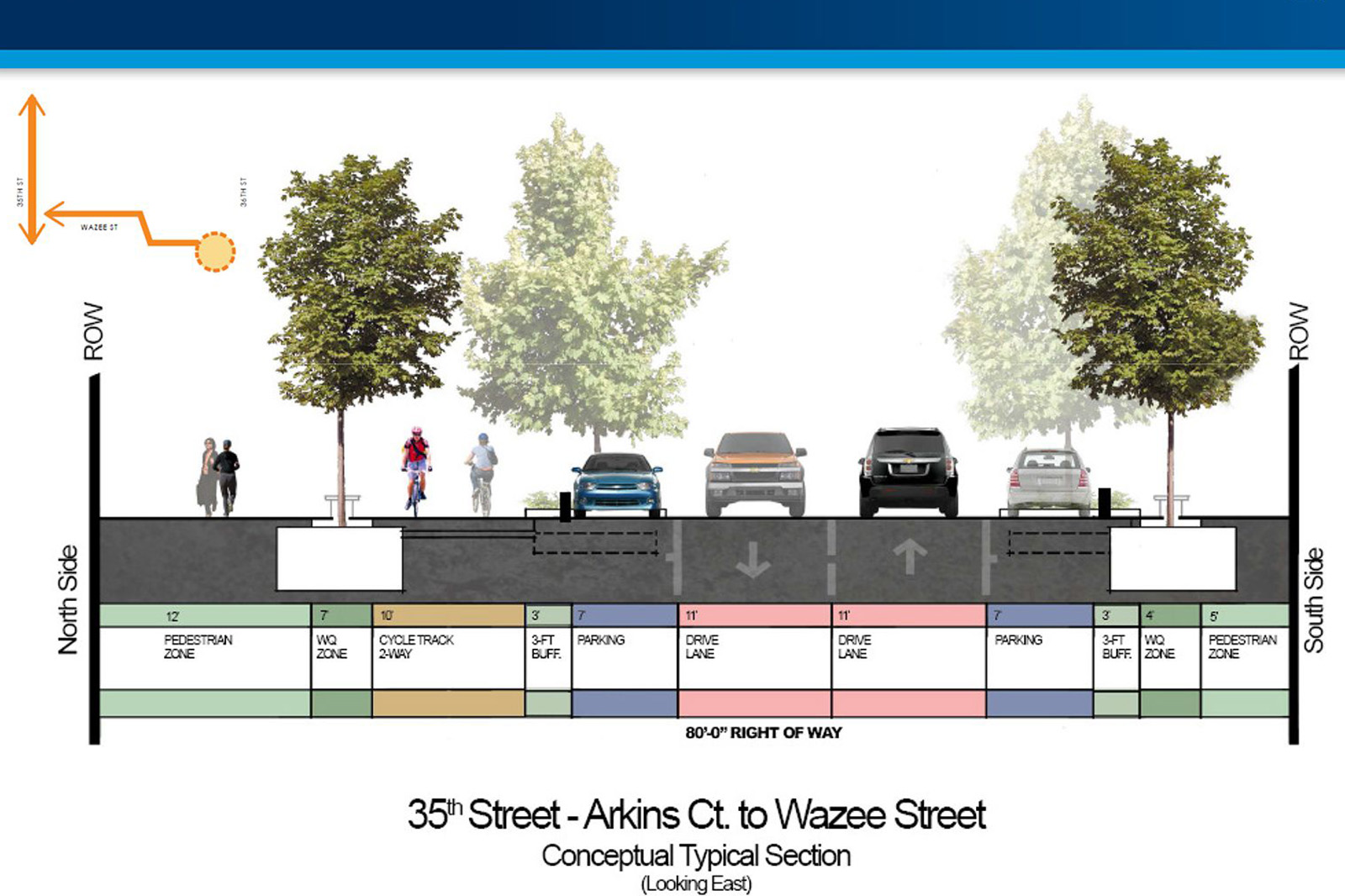
Here is a diagram from a recent presentation provided by the city’s North Denver Cornerstone Collaborative showing a conceptual cross-section for 35th Street:

An example of something similar to a woonerf in Denver may be the newly redesigned Fillmore Plaza in Cherry Creek North. It has several features found in a woonerf, such as the street and sidewalk being at the same grade and a strong pedestrian-focused design. Here’s a Google Earth street view image of Fillmore Plaza:

Here’s a Google Street View image of the Bell Street woonerf in Seattle:

As River North transitions from an automobile-oriented industrial zone to a multi-mode mixed-use district, transforming 35th into a great pedestrian street will be key in that evolution. The combination of the RiNo Pedestrian Bridge + River North Park + 35th Street Woonerf + 35th Street Pedestrian Bridge has the potential to have the same transformative impact on connecting River North to the rest of Denver as the Highland Bridge + 16th Street Plaza + Platte River Bridge + Commons Park + Riverfront Park Plaza + Millennium Bridge combination did in connecting Lower Highland with Downtown Denver.
The images below show 35th Street in its current rough-around-the-edges state:


Currently, the 35th Street Woonerf is in the conceptual design stage. Funding for construction has not yet been identified, but paying for the 35th Street Woonerf could come from a variety of sources including potentially the city, local improvement districts, and adjacent developments.
Next up in this series: Blake Street Two-Way Conversion + Bike Lanes. Stay tuned!


I just got back from Chicago this past week. I stayed in Uptown and took the L everywhere. The stop where I got off at for where I stayed was Argyle which is three stops north of the Addison stop for Wrigley Field. They are currently in full construction of a woonerf on Argyle between the L and Sheridan and its coming together fantastic. They were in the midst of laying the street pavers while I was there and the pedestrian pavers and concrete bollards/planters were already installed. It was awesome to see a woonerf coming together first-hand in an area that will definitely benefit from it. I’m so excited that Denver is going to be implementing one on 35th Street. And if it looks anywhere near as good as the woonerf on Argyle in Chicago (and I think it will look better; ours will have a cycle track), RiNo is in for a serious win here. I totally can’t wait to see it complete!