This map, from the American Intercity Bus Riders Association, attempts to show all the major intercity rail and bus routes in America. It includes Amtrak, Greyhound, and several other bus carriers.
Colorado may not have a Front Range passenger rail line yet, but it turns out you can actually travel to a lot of places without a car.
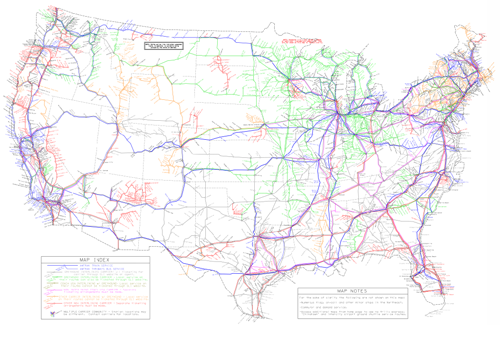
Map of Amtrak and intercity bus lines, from AIBRA.
It’s probably impossible for this kind of map to be 100% accurate all the time. In all likelihood there are some missing links, and missing carriers. But it’s still quite an impressive undertaking, and a useful tool to bookmark.


Amtrak? Sure. I use it a few times per year when I’m not in a huge hurry and want to be comfortable.
Greyhound? Not if you want to get anywhere on a schedule, have to connect with multiple routes, want to be comfortable or want to travel in an area more than 6 feet from a toilet. Greyhound has been responsible for the worst travel experiences of my life.
Want to get a refund because the driver showed up 4 hours late, took another 2 hours to “pretrip” the bus and you had to rent a car to get to your destination on time? HAHAHAHA!
Greyhound is an embarrassment to the First Group brand. FG only took them because they wanted Laidlaw Transit and they had to take the whole package.
Spend the extra money on an airline, the security “hassles” are nothing compared to the slum coaches of Greyhound.
Unfortunately, this map has TOO MANY routes on it. Many of these routes are GONE, cancelled, never to return.
An example I know personally is Ithaca, NY to Cortland, NY. There is no bus route. (You can just about do it by changing between two different city bus systems, but yuck.)
The map actually contains pretty much all carriers. The trouble is that it contains a bunch which have shut down or dropped lines since the date of publication.
The Colorado section of the map looks like it’s still accurate, but as I noted previously a lot of services elsewhere are gone since this was published bacxk in 2012.
This looks like good info, but the AIBRA link and the link to the map don’t seem to be working right now. I keep getting a web hosting site instead.
I’d love to see some coverage here about the CPR reported bill in the Colorado General Assembly about spending $10 million a year to get intercity bus service daily round trip from Denver to Glenwood Springs, five times a day round trip from Denver to Fort Collins, and six times a day round trip from Denver to Colorado Springs (restoring service lost when the FREX bus shut down).
On the substance of the map itself, one of the most striking features is the incredible difference in bus route density between Ohio and Indiana on one hand, and Kentucky on the other. Indeed, its hard to find any state less well served than Kentucky. Nevada has only a couple of lines but that’s because the vast majority of the population is located in a couple of metro areas that are served.
It’s worth noting that Greyhound is not reliable. They overbook, and can cause you to miss your connection because they bumped you to a later bus. In the old days they would always lay on an extra bus immediately when they overbooked, but reports are that they don’t do that any more.
Amtrak doesn’t do this; you can be late due to train delays but not due to being “bumped”! Frankly, neither do most bus operators who aren’t Greyhound.