Since the opening of the West Corridor Rail line in my neighborhood, I have been somewhat underwhelmed with how well it seems to be performing in terms of ridership. There are probably several reasons for this, but one of them that certainly plays a role is a lack of residential density along the line.
I recently read Vishaan Chakrabarti‘s book “A Country of Cities” in which he suggests that mass transit rail service is inefficient (i.e. it doesn’t attract enough ridership to pay for the cost of operation) at residential densities less than 30 dwelling units per acre (du/acre). Since it’s sort of difficult to imagine exactly what exactly 30 du/acre looks like, I thought I’d see how my neighborhood compared.
The West Colfax Neighborhood of Denver, shown outlined in orange in the map below, covers 540 acres. The neighborhood is served by four light rail stations and nearly 75% of the neighborhood is within one-half mile of a station as shown by the larger circles on the map (thanks to DRCOG’s new Denver Regional Equity Atlas from which I took the image). Click on the map for the full-size version.
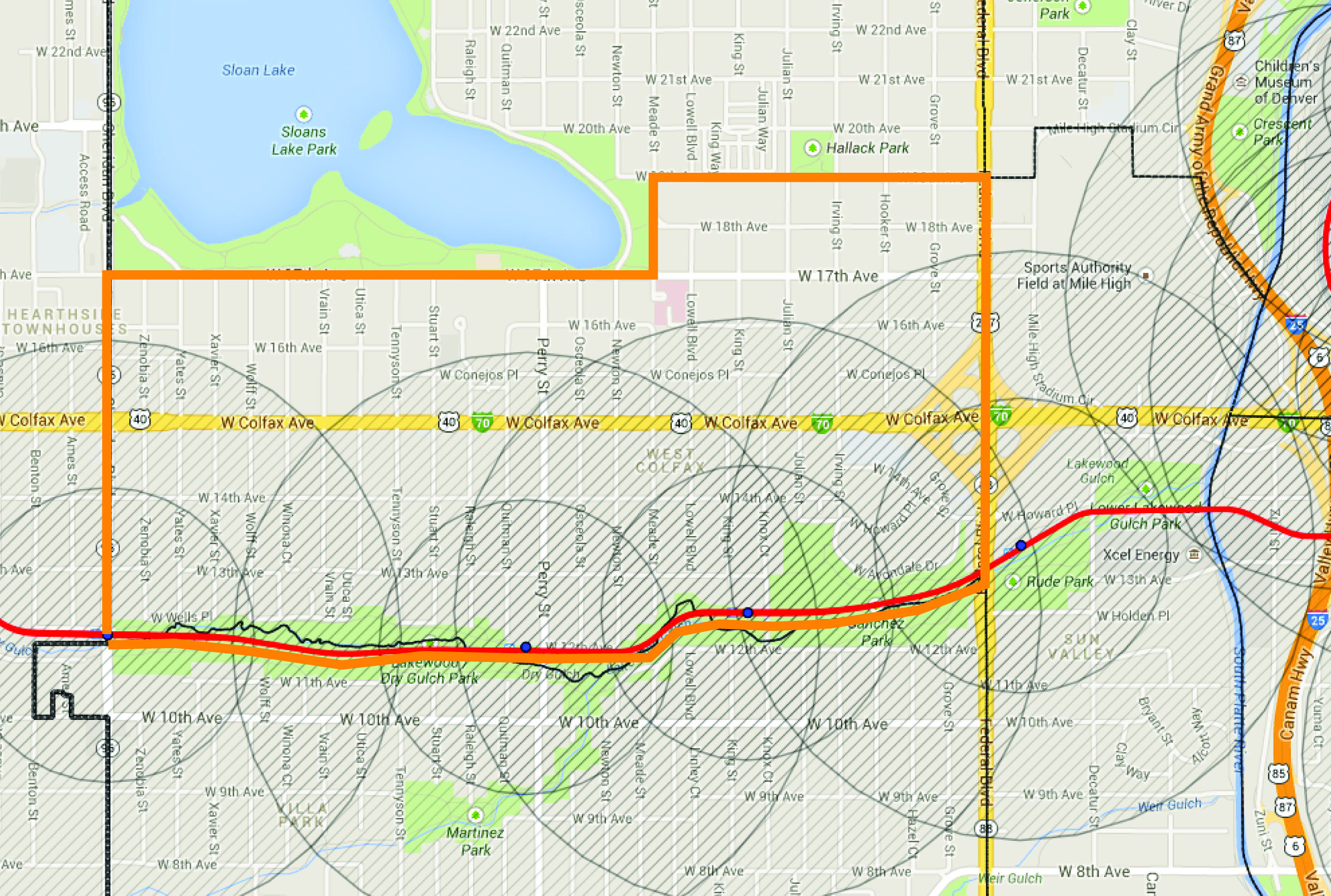
Currently there are approximately 3,600 dwelling units in the neighborhood. That means that on average there are only 6.6 dwelling units per acre. Sadly this isn’t anywhere close to Vishaan’s suggested density and probably has something to do with why I generally see a lot of mostly empty trains.
Of course I’m not one to take one person’s word as the gospel truth and I seemed to recall my urban planning professors in college quoting numbers closer to 20 du/acre, so I set out to see what sort of numbers I could find with a bit of web research. Sadly, I didn’t find many hard and fast numbers; the numbers I did find varied greatly. On the low end, a study by UC Berkeley’s Center For Future Urban Transit (PDF) suggested that light rail could be efficient between 9 and 12 du/acre depending on the size and strength of the Downtown market it served. Similarly, the LEED ND standards award credit for projects that are within a walking radius of mass transit AND contain 12 du/acre or more, suggesting that this might be an important threshold. The few other numbers I found ranged upwards from 20 to 40 du/acre. Apparently, there isn’t a clear answer, and I imagine it’s because usage depends on a multitude of other factors.
So how do all these numbers stack up in relation to West Colfax? How many more units do we need before we can cross these thresholds?
Currently I’m aware of about 150 new units that are under construction in the neighborhood. Additionally, the redevelopment of St. Anthony’s Hospital will add somewhere between 800 and 1,200 units of residential housing. Combined, this will add between 950 and 1,350 dwelling units to the neighborhood. At the high end of this estimate, adding 1,350 units to the existing 3,600 units (and dividing by 540 acres) gives us approximately 9.2 du/acre. This is barely enough to cross the 9 du/acre threshold suggested in the UC Berkeley study. To get to the seemingly better 12 du/acre threshold, we’d have to add yet another 1,530 units of housing on top of what’s currently planned. To get to Vishaan’s suggested 30 du/acre, we’d need to add over 12,600 dwelling units to the neighborhood!
Now, that’s a lot of units; just what might that look like?
Currently, Capitol Hill is probably the densest neighborhood in Denver. The neighborhood (bounded by Broadway, Colfax, Downing and 7th Ave), which covers about 430 acres, had nearly 11,300 dwelling units back in 2000 or approximately 26.3 du/acre. I apologize for the old data; it’s what I had handy. The area is probably closer to 12,000 units by now. In any case, one would have to add the entire housing stock of Capitol Hill (and then some) to the West Colfax neighborhood to reach Vishaan’s 30 du/acre recommendation. That is an enormous amount of housing. While it’s probably not very realistic given the current status of land ownership and zoning allowances in the area, I guarantee it would help to fill all those trains.


Excellent post, Chad. I think it’s important for more people to realize that the first step to car independence is for cities to embrace greater densities. No (realistic) amount of alternative transportation investment will get us there without the land use to match.
The flipside, of course, is that density without transit is also a problem; one central Denver might be facing. Optimal density levels for automobiles are significantly lower.
I wonder what densities would be needed to support arterial BRT; if that might be more appropriate for the density levels we are comfortable with.
Few things:
1. Current ridership is not far off from “opening” projections. Yes, it’s not as busy as the SE, SW, and Central Lines, but we knew it wouldn’t be. It’s doing fine.
2. RTD didn’t build these lines for people that live right next to the station. They built these lines to get suburban workers to urban jobs by making them heavy Park-N-Ride. This solved a couple things: 1)Because RTD is huge (geographically), they had to build a system that gave everyone something to vote on. Everyone did, and they were able to build a giant system quickly (This was probably somewhat short-sighted, but water under the bridge). 2) It gave them the ridership needed to meet Federal funding requirements.
3. The system is still very young. Let’s give it some time to mature. Most of the stations have or will have station area plans. This will be the single greatest opportunity to increase ridership along each line. But it will take time; in some cases, generations. For comparison, look how long TOD has taken to appear/mature in places like DC and LA.
4. Now that RTD has built their commuter system, it’s time to build a real system where it should have gone in the first place; along the busiest transit corridors. Places like Colfax, Broadway and Federal. If you want to see impressive ridership, build it where the people are and who will use it for multiple trips, not just commuting to work. Hopefully, when FasTracks is done, this will be focus (along with general bus enhancements).
I think that much of the problem with the lack of community use of the W line is less about density and the fact that light rail remains a more expensive and less appealing option for the low-income residents that (for now) remain the bulk of the population in West Colfax and Villa Park (the neighborhood to the immediate south).
9-5 Colorado did a very eye-opening survey study of local residents’ attitudes about the new light rail line (http://9to5.org/wp-content/uploads/2014/01/Left-at-the-Station.pdf) and many of them shared those very concerns. RTD’s zone fare structure means that light rail is more expensive than the equivalent bus (for indiscernible reasons as I would think it would cost RTD more to drive a bus than a light rail train for the same distance). And many low-income residents appreciate that busses have more stops and often better connections to the parts of town they need to access.
I am not sure if raising density is the answer. I think it would likely depend on the type of housing. I don’t think it’s going to help low-income residents to have gentrification of their neighborhoods, which is already happening and is of great concern. Of course if some of this density can be driven towards affordable housing, than it might be more supported by low-income residents.
But I do think its interesting generally that the busses in the neighborhood (the 16 and 9) are often more crowded that the supposedly more convenient and appealing light rail that travels through the exact same areas.
Great post. How does this relate to transit oriented development, specifically the proximity of the housing to the light rail? Why is 1/2 mile important, for instance? Could a slightly smaller development much closer to the station have an impact? (something like the southmoor station)
Adam,
A 1/2 mile is the generally accepted maximum that most people will walk to get to a transit station. Any thing built within 1/2 mile of the station is often considered transit-oriented. Increasing the density within 1/2 mile of the station insures that there are more likely users within walking distance of the station.
Hey Chad,
I was just curious, the 1/2 mile number seems perfectly viable for non-park-n-ride stations, but has anyone surveyed the license plates at the park-n-rides on the W line over the span of it’s use (since opening) to see just how far individuals are traveling to ride downtown? Then, combining that license plate registration data with eco-pass and student pass data to see the general composition of said riders to find out what kind of regularity they are riding? –one might even collect plates of cars that only drop off/pick up and note that as well– (What percentage are regulars, semi-regulars, or sporadic?) I think this kind of data would be important in determining the current number of riders and how/why they are riding. While I love the 1/2 mile radius tool, it seems like a VERY narrow measurement in understanding the FULL scope of ridership on any train-style transit system that has park-n-ride locations…
To sum up, using a density measurement in a radius around a station seems like it would apply to only VERY specific situations and cities, and could definitely not be used as a tool of measurement for all mass transit systems in any city. More data is needed to really understand the ridership of the W-Line. Otherwise, all the data you have is: How many people live near the station, and how many people ride the train from there, but a disconnect as to how many of those people who live near the station are riding from that station. Connect the dots.
Also, using one neighborhood as representative of the entire line should be avoided, as it misrepresents the data for the usage and cost of the trains over their entire journey (cost per person per mile).
Reid Ewing and Robert Cevero did a pretty definitive study in 2010 of the various factors that affect transit use, driving and walking, and found that density was actually a pretty weak predictor of transit use. Other factors such as the design of the street network and the mix of surrounding land uses were more important. The full study is available here (PDF): http://reconnectingamerica.org/assets/Uploads/travelbuiltenvironment20100511.pdf
Walkability matters a lot; it changes how far people will walk to get to the train.
Also, these projects are financed to serve these areas for many decades. Current density numbers are great, but unless we’re considering projections 20 years from now, we really can’t have an informed conversation.
I haven’t seen the west line yet; but in general, I’m genuinely shocked at how many people are waiting to depart at light rail stations downtown everyday. Those cars look pretty full to me as they pull away.
Great post. Surely more density (specifically gentrification or better yet population inversion) would be a boon to the system since these people would be traveling to downtown more often for work and for leisure. I don’t see that as a problem, moreso the natural evolution of a city.
One problem I see is the huge quantities of cheap parking downtown. Once parking becomes expensive and/or a pain in the butt downtown more people will take the light rail.
Likewise, we have no tolls for cars and basically reward people for driving, oftentimes by themselves. The roads are being subsidized to the point of being free for usage but the mass transit is not.
There are different types of mass transit rail service. They require different levels of capital investment and operating expenses and are efficient at different densities. Streetcars are lightest and cheapest, heavy rail/metro the heaviest and most expensive, light rail in between.
The Institute of Transportation Engineers says light rail needs an average residential density of 9 dwelling units per acre over the line’s catchment area, and 12 du/acre is needed for higher speed, longer distance service. Commuter rail needs 2 du/acre. (A Toolbox for Alleviating Traffic Congestion, p. 93.)
Reconnecting America has studied many station areas and developed typologies with typical densities. The minimum densities are in the 20-25 du/acre range. (http://www.reconnectingamerica.org/resource-center/books-and-reports/2008/tod-202-station-area-planning/)
Another important factor is gross density vs. net density. (Fun with Density and Transit Statistics, http://pedshed.net/?p=131)
Chakrabarti seems to be using net density, while you are using gross density to measure Denver neighborhoods. Chakrabarti shows that 30 du/acre can be achieved with townhouses, and quite a few neighborhoods in Denver have that level of density. (http://places.designobserver.com/feature/a-country-of-cities-building-hyperdensity/37899/)
Thanks for the important clarification on net v.s. gross site density. First and foremost POPULATION DENSITY not just Dwelling Unit Density must be considered for each neighborhood district. Different trip types and modes interface with each system including light rail. Perceived “Convenient” distances may vary for different populations, and a range of destinations.
Dwelling Unit Density is only one aspect of TOD criteria. In San Francisco they count bedrooms for instance—NOT Units.
I’ve only ridden the W line once (a week after its opening)and my biggest complaint was that it took way too long to get from end to end. The large umber of at grade crossings and sharp turns were major contributors to this.
Another issue is that there needs to be a second line that heads South so that people that are going South don’t have to head North before being able to transfer lines.
I agree 100%. They could eliminate mandatory stops at mile high, and pepsi center/elitch gardens during peak rush hour and make those stops by request only. That would reduce time by 3 minutes or so. They also need a plan for servicing the southern end of downtown. If you live west but work toward the Capitol, you are not going to ride the line.
Agree 100% as well. Also agree with Sean (above).
Even if we ignore the fact that getting towards the capitol end of the CBD is less than convenient (even w/ Mall and MetroRide), there remains the issue that traveling to somewhere south of the city from the W line requires a transfer at Auraria West and then waiting for the proper southbound line to come your way. Because those lines typically have only 30 minute frequencies, the prospect of doing so is impractical for anyone that could drive instead.
Take, for example, a hypothetical trip from JeffCo to Englewood station. You would go east on the W, get off at Auraria West, and then wait for the C line (up to 30 minutes) to ride the rest of the way. Or, equally unattractively, you could wait for any of the Union Station lines, then get off at Broadway to transfer to the D line going southbound. Either way, your trip would likely end up being at least 50 minutes end-to-end. A major problem when you consider that the car ride would take 25 minutes or so and likely cost less to boot.
Denver was far less dense in the early 1900’s when we had one of the largest Streetcar and inter-urban rail networks in the country. Rail transit worked then because the personal car was cost prohibitive to the majority of the population. Until commuting by car becomes less convenient/more expensive, rail will continue to lag way behind. The current density equation for mass transit only works when you have the variable of cheap oil and cheap plentiful parking.
Hey Chad,
I really appreciate how much thought and research you put into this post. I think for we urban enthusiasts, sometimes the internet doesn’t have enough content to suppress our appetite for more local planning data. The only option left is to create it ourselves. Thanks for doing this and keep up the good work! This was a very interesting read and really puts things into perspective.
Regards,
Derek
Excellent analysis and interesting viewpoint. The idea of getting rail into the higher density east side urban neighborhoods is a good one. A street car down Colfax and an elevated train on Colorado from I-25 to I-70 would be a start to connect this current rail “dead zone” — and vibrant evolving high density area — with the rest of the system.
In terms of low ridership, sadly, I don’t think density is really the issue. It is the same issues that plague the SE line — lack of parking and, especially, high fares. Unless subsidized with programs that we all pay for — “eco” passes, students and seniors — the fares are very high and just not competitive based on others options — driving and parking, for example. If fares to downtown are upwards of 8-10 dollars round trip for one individual, and parking is around $10, it only takes 2 in a car to make driving more affordable, and 3-4 people in a car is not even close. You would have to be economically irrational to take the rail.
I understand the standard refrain that RTD can’t afford to lower fares based on finances for the project. In my view, they can’t afford NOT to lower fares. Perhaps if we lowered fares, ridership would increase and revenues would also increase? Couldn’t lowering fares result in many multiple more riders — given supply and demand — and help the bottom line?
I hope that the answer is not that we just wait until downtown parking rates skyrocket so high that light rail fares finally are competitive.
I also agree with the comment that the system was made less exclusively for neighborhoods within a mile of stations than the metro region as a whole. But in order for the whole region to use it, fares need to be competitive, and there needs to be ample parking at the stations.
The fares are not that bad at all if you don’t have a car, $140 a month for three zones and $80 for two. Many companies offer the Flex Pass, discounts of 5-20% and then the company may pay for part of the remainder as well (my companies pays half). I do think you have a point as to lowering fares, it’s too bad we can’t test the idea in a vacuum. However, it’s silly to just look at the economics when choosing to take public transportation there are many other positive factors, free time, extra sleep, working, reading, less stress from not having to drive etc. I would like to see the cost of driving to increase to more realistic levels of what it costs society.
Any chance there will be a dedicated BRT (Bus Rapid Transit) lane on Colorado between I-25 (Colorado Center) and the 40th and Colorado station on the East Rail Line?
It would be great option for people going to Cherry Creek, 8th and Colorado development, and DIA.
Capital Hill is not just the most densely populated neighborhood in Denver. It is the most, or one of the top few mostly densely populated neighborhoods in the Rocky Mountain West.
Some of what we do with a transit system is hedge our bets against Peak Oil. Oil prices are likely to go up in the future since new supply is coming up less quickly than current demand trends. As oil gets more expensive, the economics of non-oil based transportation, like rail, and of very fuel efficient transportation like buses, are favored relative to personal automobiles.
Transit is powerfully impacted by parking. The less parking one builds downtown, the more likely people are to ride rail.
Ironically, suburban/regional rail actually encourages sprawl, not density, especially as we place massive park-n rides next to stops.
Not necessarily, it encourages denser development around rail stations. Without the rail, houses would have been most likely built. It allows people that might not make as much money to live a less car reliant life and have easy access to metro areas.
From the standpoint that it is further from the center of density (i.e. Denver) then it does encourage sprawl. Unless there are grocery stores next to said stops, then all those people still need a car…
” it encourages denser development around rail stations.”
….if the zoning makes that legal.
I haven’t seen the figures, but I wonder if the lack of PnR stations combined with the fact that the W trains only go to Union Station have caused some ridership problems. Most workers downtown are in the CBD, not LoDo/Unioin Station, and if I was a commuter working in the CBD, taking the W line to Union Station would be significantly less attractive than driving and parking for cheap right outside my building. I commute on the D line every day, and one of the chief motivating factors is that I can park for free in Littleton and then get off and be a 100 yard walk from my building. Both of those convenience factors are missing from the W Line in many place. And because FastTracks is essentially a commuter system, I think problems in ridership have less to do with the walkability for everyday trips to the grocery store, and more with the fact that it is not entirely convenient for commuters heading to work downtown.
Your first question is certainly valid but to sidetrack it a bit, it’s a catch 22 between having parking so people can drive to the station or to try and have multi-use real-estate so people can walk to the stations.
Your second point is a bit moot, the mall ride and circulator already fix that issue.
Yeah I see the catch 22 w/ parking v. multi-use/high density development near lines, but I have hope that the parking issue can be solved without the need for large swaths of asphalt parking (like at the mineral station). I think of places like downtown Englewood and Table Mesa PnR in Boulder as examples of how commuter parking needs can be met w/o eating up all the available land that one might otherwise use for high density development.
As far as the MallRide/MetroRide go, I don’t think my point is entirely a moot, especially when you consider that a trip on the MallRide from Union Station light rail to, say, the 16th and California station takes ~10-12 minutes. That might not seem like much, but for someone weighing the option of parking next to their building or taking the light rail and then the MallRide/MetroRide, that 10-12 minutes on the end of each day could potentially be a deal-breaker. Especially since most potential riders are going to be Americans that aren’t accustomed to the realities/inconveniences of traveling by transit (transfers, walking, etc).
interesting analysis in the article and comments, though i tend to distrust urban planning rules of thumb; even if they are carefully derived, i don’t see how they can control well for all the variables
the W line is particularly relevant for my household, as my partner works at the end of the line (Taj Mahal); she gets a subsidized pass, so she has been taking the W 2-4 times per week since it started
her very experienced observations jibe with those of mckillo above: the primary drawback is time; train takes her 50-55 minutes versus a 15 minute drive; some of this is specific to her journey (1/2 mile walk to Alameda station is about 12 minutes), but some of it is due to the design — transfers at W. Auraria are often slow or mistimed, and the W has a ponderous number of small neighborhood stops; it doesn’t seem to get much speed until past the Fed. Center; a slow train can be a time to relax, but the transfer (and being fare checked up to three times per trip) take away some of that
it’s also really too bad that RTD skimped on extending the line to downtown Golden; regardless of the economics, that decision means the line is walkable for very few residents on the entire west half; if it went downtown, we would be more likely to do evening things in Golden
“transfers at W. Auraria are often slow or mistimed,”
🙁 That’s the sort of thing which should be fixable.
“it’s also really too bad that RTD skimped on extending the line to downtown Golden;”
It is really quite incredible that RTD built / is building two lines along old railroad routes toward Golden (W line and Gold Line) and neither of them actually makes it to Golden.
Too bad it stops in the middle of nowhere- really, when was the last time somebody from Denver wanted to go to the Taj Mahal (er, “Jeffco Government Center”)?
Not only do they stop in the middle of nowhere, there is no scheduled bus service to the rest of Golden (unless you count the odd short bus that might or might not go somewhere if you call them and wait for a couple hours). There were a lot of confused and disappointed first time Golden visitors the first weekend of service who realized there was nothing at the end of the line but a closed government building and a parking garage, and if they really wanted to go to Golden they should have driven their cars.
It’s fun to drive to the train station and ride, but it’s faster and cheaper to ride my bicycle downtown.
The issue of DUS being inconvient for many downtown workers is an interesting point, and I wonder how that will impact the coming lines as they will all go to DUS. I think/hope that the downtown circulator will help b/c if I remember right it will not stop nearly as often as the mall ride, which is slower than walking.