Density is a good thing for urbanism. More density means more shops and amenities nearby, better transit service, and shorter walks. When communities are built around transit, walking, and biking instead of automobiles, more density actually makes them function better, not worse.
But what qualifies as dense? Overall city density figures are often reported, but they can be skewed by weird geographic features such as bodies of water, mountains, or giant airports inside the city limits. And even if they’re not skewed, every city has lots of variation between its neighborhoods.
A more telling statistic is the density of individual neighborhoods. Luckily, the US Census Bureau publishes density statistics for “census tracts,” which are neighborhood-sized geographic units.
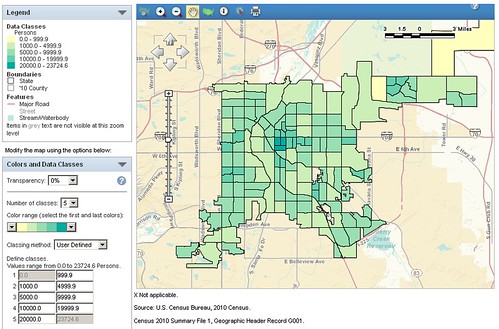
Using census.gov, it’s possible to generate maps illustrating the density of census tracts in any county in the United States. This post will explore some of Colorado’s most populated areas. If you want to make more maps of your own, here are instructions explaining how to do so.
Denver:
Residential density in Denver is centered in Capitol Hill, which contains Denver’s 3 densest census tracts. The densest one has over 23,000 people per square mile (ppsm). While that beats every other central city in Colorado, Arapahoe County has one tract that’s denser.
Arapahoe County:
Who’d have thought Colorado’s densest place wouldn’t be central Denver, but southern Glendale? At a little over 31,000 ppsm, the section of Glendale south of Cherry Creek and east of Cherry Street tops the state.
Adams County:
With 2 tracts in the 15,000 ppsm range along Colfax in Aurora, Adams’ peak is half that of Arapahoe, but still high.
Jefferson County:
Belmar is beginning to look like a true downtown. At 13,000 ppsm it’s JeffCo’s densest tract.
Boulder – Boulder County:
Although it can’t match Denver’s density, Boulder’s 3 tracts above 10,000 ppsm and peak above 15,000 ppsm is very respectable. It’s about the same as Colfax Avenue in old Aurora.
Colorado Springs – El Paso County:
With a peak density of just 9,000 ppsm, the Springs doesn’t have any neighborhoods that even come close to approaching Boulder, much less Denver. Oddly, the core urban neighborhoods don’t appear to be any denser than the outer suburban ones.
Fort Collins – Larimer County:
Fort Collins has one neighborhood that just barely squeaks above 10,000 ppsm.
Pueblo – Pueblo County:
Like the Springs, Pueblo’s core neighborhoods are about the same density as its outer ones; in fact, the densest tract is the one at the very north end of the city, with just under 8,000 ppsm.
In a future post, we’ll look at the neighborhood density of large cities around the country, including New York and Los Angeles.


City densities can be skewed, and so can census tract data. The Glendale examples is a good demonstration of skewed data. That 31,000 ppsm tract is just a few blocks of nothing but apartments and if it was part of the larger census tract comparable in size to those in capitol hill it’s density would be much lower. Since Census tracts have no uniform size small tracts with a few dense buildings can skew the data significantly higher. On the flip side large tracts that go from dense areas to not so dense areas can be skewed lower when comparing them with smaller tracts.
Interesting to look at however.
Are those quantities normalized by the area of the tract? I can never trust these choropleths without knowing they analyst actually did so.
census.gov can show density by 5-digit zip code (you have to map the whole state, then zoom); the zip code boundaries are subject to the same flaws as census tracts, but seem to break a bit better in Denver; density by zip shows 80203 (Capital Hill and environs) as densest – a snap here:
https://www.dropbox.com/s/neqcqba5jgjm6on/centraldenver_density.png
another case for Aaron’s point is Baker, a single census tract that is only about 20% residential use; Baker’s residential core is not especially high density, but it’s not well-represented by the density of the whole neighborhood area
what this illustrates is that a city scale, and because of the limitations at census.gov, we don’t have small enough units available do show density as we experience on the street
I’d be curious to see how far you’d have to go to get census tracts more dense than Glendale and Capitol Hill. My guess is that there are no such tracts anywhere in Wyoming, Montana, North Dakota, South Dakota, Idaho, or even Utah or Nebraska or Kansas or Oklahoma. New Mexico and Arizona have some decent sized cities, but lack the really intensely developed central cities that Denver does. I suspect that the only city with higher census tract density than Denver this side of the casades is Las Vegas and to the East there may be no census tracts so dense until you reach the I-35 corridor in Texas and Chicago.
Another question I’m curious about is how far you’d have to go to find another middle class predominantly black neighborhood like some of the census tracts in Park Hill in Denver. There might be one in Phoenix, but middle class black neighborhoods are extremely scarce outside the Northeast and the South.
Update: Glendale doesn’t quite beat Los Angeles which has a neighborhood roughly twice as densely populated. Houston has only one census tract more dense despite its famous lack of zoning. No census tracts in Atlanta or Tampa or Detroit or Phoenix on Minneapolis or Saint Louis or Portland, OR are so dense, although Seattle and San Diego both do.