 |
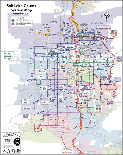
The map at right shows bus routes in Salt Lake City, with each route color coded to show the frequency of buses. What a genius idea.
One of the many reasons rail systems are usually more popular with casual riders than bus systems is that rail systems are much easier to understand. With only five routes, RTD’s light rail map is a breeze to figure out. On the other hand, the bus map is so complex that it’s barely comprehensible even to experts.
Part of the problem is that any large bus agency (RTD included) will necessarily have a lot of routes that don’t come very often, and generally aren’t used by very many people. Those routes clutter up their maps, making the overall bus system harder to understand for anyone hoping to know where they can use transit to travel quickly and easily.
One solution to this problem is to produce a separate map that only shows frequent service routes. Such maps are incredibly useful, but their weakness is that users simply looking for a system map may not be aware that a separate frequent service one exists. It’s asking a lot for people to know what kind of bus map they should ask for.
So why not put the info on the regular map? Do what Salt Lake City’s transit agency has done here, and show the frequent routes in a different color.
Sure, it adds a little bit of extra clutter, but it also adds a tremendous amount of extremely useful data. The clutter cost is low in terms of information provided.
To its credit, RTD’s bus map does show some premium services with different colors. Limited stop buses get a purple dashed line, express buses get red, etc. But a bus that comes every 10 minutes is shown with the same line as a bus that comes once per hour.
I like limited stop routes, but knowing there’s a limited stop overlay on Colfax is far less important than knowing that buses there come so often that riders can just walk up to a stop and never have to wait very long for a bus. RTD’s map isn’t showing the more important piece of information.
Incidentally, Salt Lake City has a very impressive transit system for a city of its size. It’s the 50th largest metropolitan area in the US, with a regional population equivalent to Birmingham, AL and Rochester, NY. It is less than half the size of metropolitan Denver. And yet it has a 35-mile light rail system, a 44-mile commuter rail line, bus priority routes, and a modern streetcar under construction. It is probably the most impressive small city network in the country.


how about line thickness gradients for each line based on frequency of bus times on the route?
Part of the problem is there are so few frequent service routes: http://g.co/maps/zed37
Nice map!
We should keep Dan’s comments in mind about the quality of SLC’s transit system when people are agruing against Denver bidding for the Olympics in a few years due to the cost. The main reason SLC has such outstanding infrastructure in place is because of the huge push to build and improve the system they made prior to hosting the Winter Olympics.