During a recent trip to Brighton England, a sea-side town an hour south of London, several interesting bicycle infrastructure treatments caught my eye. Over the next week I will show how these treatments could be useful in Denver.
Shared bicycle/pedestrian zones:
Denver already has shared paths for bicycle and pedestrian, however they are not well marked, decreasing their safety and usefulness. On Denver’s bicycle maps these routes are called multi-use paths. Examples include 20th Street from Coors Field to Central Street linking Highlands to Downtown, and the sidewalks between the Webb Building, 15th Street and Colfax, an important link between the new Bannock Street Cycle Track and Downtown. Both routes provide connectivity, but one would pretty much have to look at the city bike map to know they exist. Poor marking of shared-use paths lead to conflicts between pedestrians and cyclists, and it makes enforcement of non-shared sidewalks more problematic. If some sidewalks are shared and some sidewalks are not, then clear designation tools are essential. Holding the public responsible for knowing which sidewalks they are allowed to ride on and which sidewalks are off limits is difficult if one can’t tell the difference between the two. For instance, the sidewalk on the north side of Buchtel Blvd. between DU and Franklin Street is a shared use path, but not a single sign or pavement marking indicates this.
Below are photos of the sidewalk path in front of the Webb building. Currently half is designated for cyclists and half of pedestrians but the markings are small and unclear.
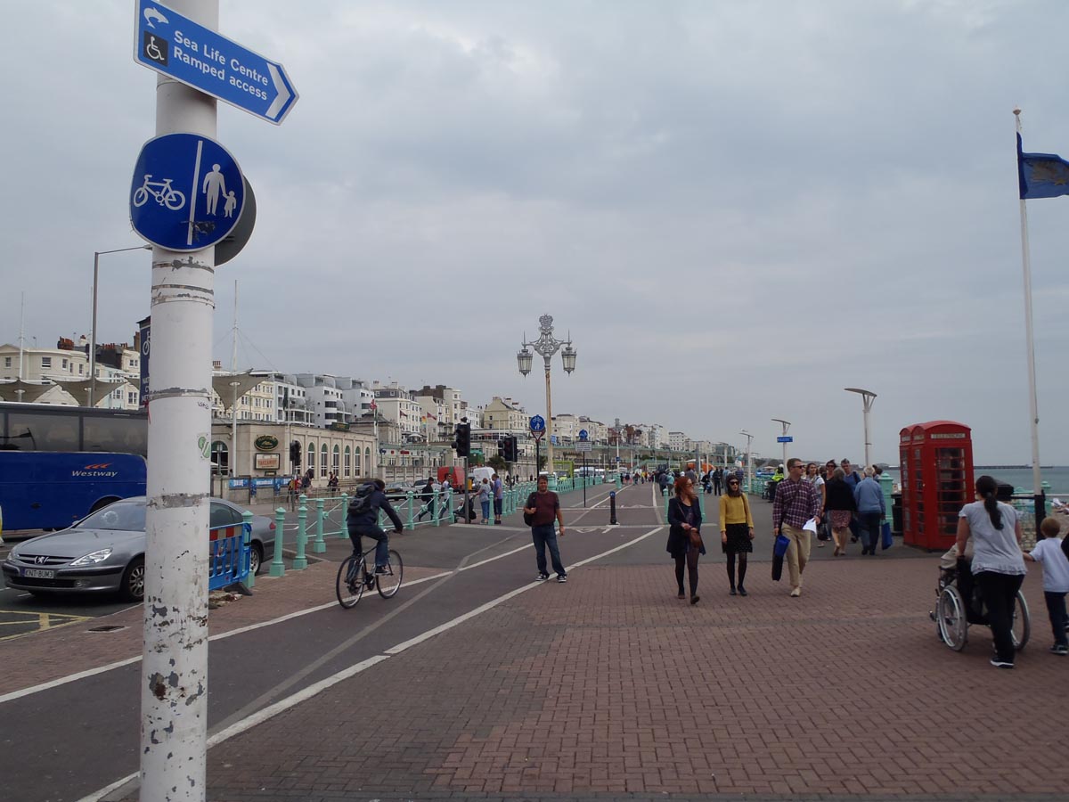
In Brighton, and many other places around the world, simple signage and pavement markings have been used to indicate a shared-use path, thus providing greater connectivity and reducing the chance of conflict between pedestrians and bicycles.
Below is a photo of the Brighton beachfront path shared by bicycles and pedestrians.
Two simple tools are used here:
1, A circular blue sign clearly designating that this space is shared by pedestrians and cyclists.
2, Pavement markings show the route for cyclists through heavy traffic areas.
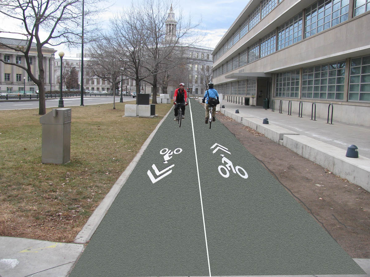
Above is a photoshop images of the Webb building sidewalk with pavement markings like that used in Brighton. It’s easy to see how this could help increase connectivity and decrease conflict between cyclists and pedestrians in this and other locations.
While there will be a cost to increasing the use of pavement markings and signage, think of the number of miles we mark for automobiles. Think of the paint on Colorado Blvd. alone. Allocating resources to clearly sign and mark a limited number of shared-use zones for pedestrians and bicycles is a good investment in health and safety by comparison.


Thanks for this post. It’s always worth taking a look at how other cities work. And I really liked the point about how much more we invest in marking lanes for motor vehicles. Well done.
Better markings for bike infrastructure is necessary if we expect people to use it. Anyone can get in a car and know exactly where they’re allowed to go and how to get there by just looking out the window. Bicyclists on the other hand must bring a map or memorize routes before hand. Even then unmarked routes lead to danger for the cyclists and annoyance for the motorist. If there’s no marking on the street to let people know what’s allowed then how does the motorist know that the cyclist isn’t just riding in the middle of the lane to be an ass?
I always try to stick to marked routes so that motorists are both aware of me and willing to give me the benefit of the doubt as a cyclist. It may seem like motorists should be doing that anyway but we all know that isn’t how it works. Bike lanes and sharrows on every route in Denver would make both groups safer and make it easier for cyclists in particular to get around easily and safely.
Great idea in general. However, I don’t think this would really work for the area in front of the Webb building. This area is a little different in that it isn’t really a shared use. The city is purposely separating the ped and bike traffic, peds to walk along the “cut-thought” sidewalk next to the building, and bikes to travel along the sidewalk next to Colfax. Here you probably just need some better signage and some bike lane marking along the sidewalk next to Colfax. Cheap and easy.
Good conversation. I always thought it was odd to try to prohibit pedestrian traffic on the sidewalk next to Colfax at the Webb building (or any urban sidewalk for that matter). Doing so in an urban office setting only presents an opportunity for cyclists and pedestrians to get mad at each other, both thinking that they have the right-of-way no matter what the sign says. I think most cyclists are generally cautious on sidewalks and typically try to ride in the street when possible and safe. The Brighton example is great, but more applicable in a park or large plaza environment like Wash park, the Cherry Creek trail, or 16th street mall. How unfortunate it is that cyclists can’t enjoy a ride down the 16th street mall. A ‘pedestrian’ mall that allows buses but no bikes – a missed opportunity if you ask me (and I know you didn’t). Wish I could climb in the Delorean and go back to the future. Thanks for the post John!
I like the cycle track/path in your rendering in place of the dirt/crushed gravel path that no one seems to use. Pedestrians walking along Colfax do not like that detour and generally ignore the sign that makes them go to the right closer to the Webb building. For cyclists that cycling link is vital to those coming from the south on Bannock to get to either 15th and further into downtown or to get to 16th Ave via Cleveland and a two lane path on that dirt path is more direct for either purpose than going around closer to Colfax.
Would like to see that cycle track extended further to the right (in the rendering) on 15th to the future cycle track on the left side of 15th. Also would like some markers added for cyclists going to and from the sidewalk/cycletrack on the Webb building to Cleveland like they added to make the 16th Ave to 16th street mall transition less confusing and clearly communicates to pedestrians that it’s okay for cyclists to be there.
I am all for bike lanes with enhanced buffers, or bike tracks on all our streets. Normal bike lanes are frequently ignored by many riders both for being a little out of the way, and not really providing any extra path security. I think of the 16th ave bike lanes and the number of riders on 17th ave as a ready example.
If we want bikes to be valid transportation vs a hobby then we need to treat them that way- same access to the same grid. Building streets without well defined bike access is like building streets without sidewalks- which helped ruined many a suburb.
That said the idea for Colfax is at least a one block improvement. And sometimes things have to be fought for one block at a time.